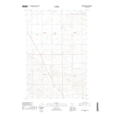
2020 Map of Gouchnour Ranch
USGS Topo · Published 2020About this map
Gouchnour Ranch sits at the heart of this Lewis and Clark County landscape, a region defined by an intricate network of water management systems essential for high plains agriculture. The map documents numerous irrigation features including Lame Ditch, Bickle Burke Ditch, and the Florence Canal, which divert water across the varying elevations. These man-made channels interact with natural drainage patterns like Hogan Slough and Spring Cr. The land is partitioned into large parcels by a series of rural routes such as Camp Walker Rd and Allen Rd, reflecting the expansive ranching and farming operations of the Montana interior. Natural drainages like Dry Cr and Hogan Cr provide the primary relief in the southern sections, illustrating the transition from managed irrigation to more traditional livestock range.
Find a feature on this map
17 named features on this map. Tap any name to fly to it.
Don’t see what you’re looking for? This feature index may not catch every label — zoom into the map to look around manually.
Map Details
Editions of this 2020 Gouchnour Ranch Map
This is the sole edition of this map. No revisions or reprints were ever made.
Other maps of this area

1920 · Choteau
USGS Topo · 1:125,000

1943 · Hogan
USGS Topo · 1:125,000

1955 · Choteau
USGS Topo · 1:250,000

1957 · Choteau
USGS Topo · 1:250,000

1958 · Choteau
USGS Topo · 1:250,000

1960 · Gilman
USGS Topo · 1:62,500
1960 · Freezeout Lake
USGS Topo · 1:62,500

1962 · Choteau
USGS Topo · 1:250,000
1962 · Bowmans Corners
USGS Topo · 1:24,000
1963 · Bowmans Corners NW
USGS Topo · 1:24,000