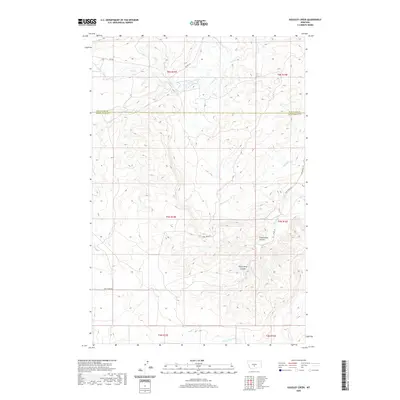
2020 Map of Gougley Creek
USGS Topo · Published 2020About this map
The border of Wheatland Co and Sweet Grass Co divides this rural Montana landscape, characterized by a series of deep drainage channels and seasonal waterways. The topography is defined by significant landmarks like Fredrickson Coulee and Sheep Shed Coulee, which cut through the high plains. A network of ranch roads, including Tony Creek Rd and Cooney Rd, provides access to the interior, tracing the paths of local water sources such as Gougley Cr and Fish Cr. The drainage patterns are intricate, with smaller tributaries like Sadie Cr and Dead Beaver Cr flowing toward larger basins. This map reflects a contemporary view of the region's ranching infrastructure, where the placement of small lanes like Adams Ln and crossings like Red Bridge Rd follow the dictates of the winding coulees and creek beds.
Find a feature on this map
20 named features on this map. Tap any name to fly to it.
Don’t see what you’re looking for? This feature index may not catch every label — zoom into the map to look around manually.
Map Details
Editions of this 2020 Gougley Creek Map
This is the sole edition of this map. No revisions or reprints were ever made.
Other maps of this area

1889 · Big Snowy Mountain
USGS Topo · 1:250,000

1893 · Big Snowy Mountain
USGS Topo · 1:250,000

1954 · Roundup
USGS Topo · 1:250,000

1958 · Roundup
USGS Topo · 1:250,000
1985 · Upper Glaston Lake
USGS Topo · 1:24,000

1985 · Jim Creek
USGS Topo · 1:24,000
1985 · Gougley Creek
USGS Topo · 1:24,000
1985 · Melville NW
USGS Topo · 1:24,000
1985 · Gibson SW
USGS Topo · 1:24,000
1985 · Melville
USGS Topo · 1:24,000