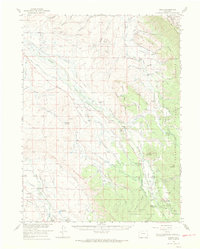
1956 Map of Gould
USGS Topo · Published 1969About this map
Manning Mine and Capron Mine anchor the northern reaches of this high-altitude landscape, reflecting the persistent extraction efforts in Jackson County during the mid-20th century. The settlement at Gould sits near the base of the Medicine Bow Mountains, serving as a focal point for a ranching economy that lines the valleys of the Michigan River and Illinois River. Notable family operations like the Illinois Ranch, Stelbar-Connor Ranch, and Lobau Ranch are meticulously documented, tracing the human footprint across the basins. Public land management is evident through the presence of the Michigan River Ranger Sta and the Roosevelt National Forest boundary. The map also records essential infrastructure for water and transport, including the Overland Ditch and the Haworth Sch, providing a clear view of the area's development before modern expansion.
Find a feature on this map
85 named features on this map. Tap any name to fly to it.
Don’t see what you’re looking for? This feature index may not catch every label — zoom into the map to look around manually.
Map Details
Editions of this 1956 Gould Map
2 editions found
Other maps of this area

1915 · Longs Peak
USGS Topo · 1:125,000

1916 · Home
USGS Topo · 1:125,000

1919 · Rocky Mountain National Park
USGS Topo · 1:125,000

1920 · Home
USGS Topo · 1:125,000

1954 · Greeley
USGS Topo · 1:250,000

1954 · Craig
USGS Topo · 1:250,000

1955 · Eagle Hill
USGS Topo · 1:24,000

1955 · Gould
USGS Topo · 1:24,000

1955 · Owl Ridge
USGS Topo · 1:24,000

1955 · Shipman Mountain
USGS Topo · 1:24,000