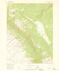
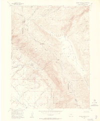
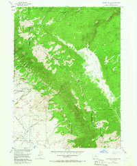
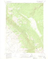
1955 Map of Shipman Mountain
USGS Topo · Published 1957About this map
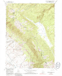
The high alpine intersection of Roosevelt National Forest, Medicine Bow National Forest, and Routt National Forest dominates this 1950s survey. Centered on Shipman Mountain, the terrain showcases a complex drainage system where the South Shipman Fork and North Fork Grace Creek carve through the northern slopes, while the Canadian River snakes across the southwestern corner. The map reveals the early infrastructure of the region, specifically the intricate water management of the East Sand Hills area through the Ute Ditch, Lizzie Ditch, and Kerr Ditch.
Find a feature on this map
35 named features on this map. Tap any name to fly to it.
Don’t see what you’re looking for? This feature index may not catch every label — zoom into the map to look around manually.
Map Details
Editions of this 1955 Shipman Mountain Map
6 editions found
Historical Maps of Larimer County Through Time
254 maps found

1905 Mount Olympus
Larimer County, CO

1907 Livermore
Larimer County, CO

1907 Mount Olympus
Larimer County, CO

1909 Livermore
Larimer County, CO

1916 Home
Larimer County, CO

1920 Home
Larimer County, CO

1955 Old Roach
Larimer County, CO

1955 Shipman Mountain
Larimer County, CO

1957 Longs Peak
Larimer County, CO

1957 Mc Henrys Peak
Larimer County, CO

1957 Trail Ridge
Larimer County, CO

1958 Fall River Pass
Larimer County, CO

1960 Buckeye
Larimer County, CO

1960 Haystack Gulch
Larimer County, CO

1960 Livermore
Larimer County, CO

1960 Livermore Mountain
Larimer County, CO

1961 Longs Peak
Larimer County, CO

1961 Masonville
Larimer County, CO

1962 Big Narrows
Larimer County, CO

1962 Boston Peak
Larimer County, CO

1962 Buckhorn Mountain
Larimer County, CO

1962 Carter Lake Reservoir
Larimer County, CO

1962 Chambers Lake
Larimer County, CO

1962 Comanche Peak
Larimer County, CO

1962 Crystal Mountain
Larimer County, CO

1962 Drake
Larimer County, CO

1962 Glen Haven
Larimer County, CO

1962 Horsetooth Reservoir
Larimer County, CO

1962 Kinikinik
Larimer County, CO

1962 Masonville
Larimer County, CO

1962 Panorama Peak
Larimer County, CO

1962 Pinewood Lake
Larimer County, CO

1962 Pingree Park
Larimer County, CO

1962 Poudre Park
Larimer County, CO

1962 Rawah Lakes
Larimer County, CO

1962 Rustic
Larimer County, CO

1967 Cherokee Park
Larimer County, CO

1967 Crazy Mountain
Larimer County, CO

1967 Deadman
Larimer County, CO

1967 Diamond Peak
Larimer County, CO

1967 Eaton Reservoir
Larimer County, CO

1967 Glendevey
Larimer County, CO

1967 Round Butte
Larimer County, CO

1967 Sand Creek Pass
Larimer County, CO

1967 South Bald Mountain
Larimer County, CO

1967 Table Mountain
Larimer County, CO

1967 Virginia Dale
Larimer County, CO

1972 Carr SW
Larimer County, CO

1972 Carr West
Larimer County, CO

2010 Buckeye
Larimer County, CO

2010 Carr SW
Larimer County, CO

2010 Carr West
Larimer County, CO

2010 Carter Lake Reservoir
Larimer County, CO

2010 McHenrys Peak
Larimer County, CO

2010 Round Butte
Larimer County, CO

2010 Table Mountain
Larimer County, CO

2010 Trail Ridge
Larimer County, CO

2010 Virginia Dale
Larimer County, CO

2011 Big Narrows
Larimer County, CO

2011 Boston Peak
Larimer County, CO

2011 Buckhorn Mountain
Larimer County, CO

2011 Chambers Lake
Larimer County, CO

2011 Cherokee Park
Larimer County, CO

2011 Comanche Peak
Larimer County, CO

2011 Crazy Mountain
Larimer County, CO

2011 Crystal Mountain
Larimer County, CO

2011 Deadman Park
Larimer County, CO

2011 Diamond Peak
Larimer County, CO

2011 Drake
Larimer County, CO

2011 Eaton Reservoir
Larimer County, CO

2011 Fall River Pass
Larimer County, CO

2011 Glendevey
Larimer County, CO

2011 Glen Haven
Larimer County, CO

2011 Haystack Gulch
Larimer County, CO

2011 Horsetooth Reservoir
Larimer County, CO

2011 Kinikinik
Larimer County, CO

2011 Livermore
Larimer County, CO

2011 Livermore Mountain
Larimer County, CO

2011 Longs Peak
Larimer County, CO

2011 Masonville
Larimer County, CO

2011 Old Roach
Larimer County, CO

2011 Panorama Peak
Larimer County, CO

2011 Pinewood Lake
Larimer County, CO

2011 Pingree Park
Larimer County, CO

2011 Poudre Park
Larimer County, CO

2011 Rawah Lakes
Larimer County, CO

2011 Rustic
Larimer County, CO

2011 Sand Creek Pass
Larimer County, CO

2011 Shipman Mountain
Larimer County, CO

2011 South Bald Mountain
Larimer County, CO

2013 Big Narrows
Larimer County, CO

2013 Boston Peak
Larimer County, CO

2013 Buckeye
Larimer County, CO

2013 Buckhorn Mountain
Larimer County, CO

2013 Carr SW
Larimer County, CO

2013 Carr West
Larimer County, CO

2013 Carter Lake Reservoir
Larimer County, CO

2013 Chambers Lake
Larimer County, CO

2013 Cherokee Park
Larimer County, CO

2013 Comanche Peak
Larimer County, CO

2013 Crazy Mountain
Larimer County, CO

2013 Crystal Mountain
Larimer County, CO

2013 Deadman Park
Larimer County, CO

2013 Diamond Peak
Larimer County, CO

2013 Drake
Larimer County, CO

2013 Eaton Reservoir
Larimer County, CO

2013 Fall River Pass
Larimer County, CO

2013 Glendevey
Larimer County, CO

2013 Glen Haven
Larimer County, CO

2013 Haystack Gulch
Larimer County, CO

2013 Horsetooth Reservoir
Larimer County, CO

2013 Kinikinik
Larimer County, CO

2013 Livermore
Larimer County, CO

2013 Livermore Mountain
Larimer County, CO

2013 Longs Peak
Larimer County, CO

2013 Masonville
Larimer County, CO

2013 McHenrys Peak
Larimer County, CO

2013 Old Roach
Larimer County, CO

2013 Panorama Peak
Larimer County, CO

2013 Pinewood Lake
Larimer County, CO

2013 Pingree Park
Larimer County, CO

2013 Poudre Park
Larimer County, CO

2013 Rawah Lakes
Larimer County, CO

2013 Round Butte
Larimer County, CO

2013 Rustic
Larimer County, CO

2013 Sand Creek Pass
Larimer County, CO

2013 Shipman Mountain
Larimer County, CO

2013 South Bald Mountain
Larimer County, CO

2013 Table Mountain
Larimer County, CO

2013 Trail Ridge
Larimer County, CO

2013 Virginia Dale
Larimer County, CO

2016 Big Narrows
Larimer County, CO

2016 Boston Peak
Larimer County, CO

2016 Buckeye
Larimer County, CO

2016 Buckhorn Mountain
Larimer County, CO

2016 Carr SW
Larimer County, CO

2016 Carr West
Larimer County, CO

2016 Carter Lake Reservoir
Larimer County, CO

2016 Chambers Lake
Larimer County, CO

2016 Cherokee Park
Larimer County, CO

2016 Comanche Peak
Larimer County, CO

2016 Crazy Mountain
Larimer County, CO

2016 Crystal Mountain
Larimer County, CO

2016 Deadman Park
Larimer County, CO

2016 Diamond Peak
Larimer County, CO

2016 Drake
Larimer County, CO

2016 Eaton Reservoir
Larimer County, CO

2016 Fall River Pass
Larimer County, CO

2016 Glendevey
Larimer County, CO

2016 Glen Haven
Larimer County, CO

2016 Haystack Gulch
Larimer County, CO

2016 Horsetooth Reservoir
Larimer County, CO

2016 Kinikinik
Larimer County, CO

2016 Livermore
Larimer County, CO

2016 Livermore Mountain
Larimer County, CO

2016 Longs Peak
Larimer County, CO

2016 Masonville
Larimer County, CO

2016 McHenrys Peak
Larimer County, CO

2016 Old Roach
Larimer County, CO

2016 Panorama Peak
Larimer County, CO

2016 Pinewood Lake
Larimer County, CO

2016 Pingree Park
Larimer County, CO

2016 Poudre Park
Larimer County, CO

2016 Rawah Lakes
Larimer County, CO

2016 Round Butte
Larimer County, CO

2016 Rustic
Larimer County, CO

2016 Sand Creek Pass
Larimer County, CO

2016 Shipman Mountain
Larimer County, CO

2016 South Bald Mountain
Larimer County, CO

2016 Table Mountain
Larimer County, CO

2016 Trail Ridge
Larimer County, CO

2016 Virginia Dale
Larimer County, CO

2019 Big Narrows
Larimer County, CO

2019 Boston Peak
Larimer County, CO

2019 Buckeye
Larimer County, CO

2019 Buckhorn Mountain
Larimer County, CO

2019 Carr SW
Larimer County, CO

2019 Carr West
Larimer County, CO

2019 Carter Lake Reservoir
Larimer County, CO

2019 Chambers Lake
Larimer County, CO

2019 Cherokee Park
Larimer County, CO

2019 Comanche Peak
Larimer County, CO

2019 Crazy Mountain
Larimer County, CO

2019 Crystal Mountain
Larimer County, CO

2019 Deadman Park
Larimer County, CO

2019 Diamond Peak
Larimer County, CO

2019 Drake
Larimer County, CO

2019 Eaton Reservoir
Larimer County, CO

2019 Fall River Pass
Larimer County, CO

2019 Glendevey
Larimer County, CO

2019 Glen Haven
Larimer County, CO

2019 Haystack Gulch
Larimer County, CO

2019 Horsetooth Reservoir
Larimer County, CO

2019 Kinikinik
Larimer County, CO

2019 Livermore
Larimer County, CO

2019 Livermore Mountain
Larimer County, CO

2019 Longs Peak
Larimer County, CO

2019 Masonville
Larimer County, CO

2019 McHenrys Peak
Larimer County, CO

2019 Old Roach
Larimer County, CO

2019 Panorama Peak
Larimer County, CO

2019 Pinewood Lake
Larimer County, CO

2019 Pingree Park
Larimer County, CO

2019 Poudre Park
Larimer County, CO

2019 Rawah Lakes
Larimer County, CO

2019 Round Butte
Larimer County, CO

2019 Rustic
Larimer County, CO

2019 Sand Creek Pass
Larimer County, CO

2019 Shipman Mountain
Larimer County, CO

2019 South Bald Mountain
Larimer County, CO

2019 Table Mountain
Larimer County, CO

2019 Trail Ridge
Larimer County, CO

2019 Virginia Dale
Larimer County, CO

2022 Big Narrows
Larimer County, CO

2022 Boston Peak
Larimer County, CO

2022 Buckeye
Larimer County, CO

2022 Buckhorn Mountain
Larimer County, CO

2022 Carr SW
Larimer County, CO

2022 Carr West
Larimer County, CO

2022 Carter Lake Reservoir
Larimer County, CO

2022 Chambers Lake
Larimer County, CO

2022 Cherokee Park
Larimer County, CO

2022 Comanche Peak
Larimer County, CO

2022 Crazy Mountain
Larimer County, CO

2022 Crystal Mountain
Larimer County, CO

2022 Deadman Park
Larimer County, CO

2022 Diamond Peak
Larimer County, CO

2022 Drake
Larimer County, CO

2022 Eaton Reservoir
Larimer County, CO

2022 Fall River Pass
Larimer County, CO

2022 Glendevey
Larimer County, CO

2022 Glen Haven
Larimer County, CO

2022 Haystack Gulch
Larimer County, CO

2022 Horsetooth Reservoir
Larimer County, CO

2022 Kinikinik
Larimer County, CO

2022 Livermore
Larimer County, CO

2022 Livermore Mountain
Larimer County, CO

2022 Longs Peak
Larimer County, CO

2022 Masonville
Larimer County, CO

2022 McHenrys Peak
Larimer County, CO

2022 Old Roach
Larimer County, CO

2022 Panorama Peak
Larimer County, CO

2022 Pinewood Lake
Larimer County, CO

2022 Pingree Park
Larimer County, CO

2022 Poudre Park
Larimer County, CO

2022 Rawah Lakes
Larimer County, CO

2022 Round Butte
Larimer County, CO

2022 Rustic
Larimer County, CO

2022 Sand Creek Pass
Larimer County, CO

2022 Shipman Mountain
Larimer County, CO

2022 South Bald Mountain
Larimer County, CO

2022 Table Mountain
Larimer County, CO

2022 Trail Ridge
Larimer County, CO

2022 Virginia Dale
Larimer County, CO