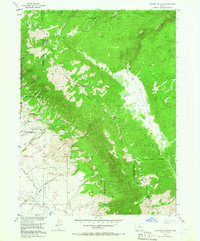
1955 Map of Shipman Mountain
USGS Topo · Published 1965About this map
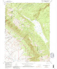
Shipman Mountain dominates the high-altitude divide between the Routt National Forest and Roosevelt National Forest in this mid-1950s survey. The landscape is defined by the sharp vertical contrast between the Medicine Bow Range and the lower-elevation East Sand Hills to the southwest. This map reveals a complex hydraulic system vital to the region's ranching and water management history, including the Lizzie Ditch, William Kerr Ditch, and Medicine Bow Ditch. These man-made channels diverted water from high-country sources like the Canadian River and Sand Creek to sustain operations in the valley. Historical movement through the area is anchored by Ute Pass, while a network of creeks including Jenkins Creek and the North Fork Medicine Bow River carve through the heavily forested mountain slopes.
Find a feature on this map
41 named features on this map. Tap any name to fly to it.
Don’t see what you’re looking for? This feature index may not catch every label — zoom into the map to look around manually.
Map Details
Editions of this 1955 Shipman Mountain Map
6 editions found
Other maps of this area

1916 · Home
USGS Topo · 1:125,000

1920 · Home
USGS Topo · 1:125,000

1950 · Kings Canyon
USGS Topo · 1:24,000

1952 · Kings Canyon
USGS Topo · 1:24,000

1954 · Greeley
USGS Topo · 1:250,000

1954 · Craig
USGS Topo · 1:250,000

1955 · Old Roach
USGS Topo · 1:24,000

1955 · Eagle Hill
USGS Topo · 1:24,000

1955 · Shipman Mountain
USGS Topo · 1:24,000

1955 · Gould NW
USGS Topo · 1:24,000