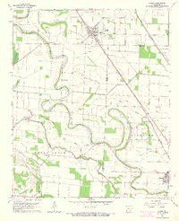
1964 Map of Gould
USGS Topo · Published 1965About this map
Gould serves as the primary hub in this mid-1960s agricultural landscape, where the Missouri Pacific railroad cuts a diagonal line through the Delta flatlands. The map reveals an intricate network of drainage and transport, defined by the winding course of Choctaw Bayou and a system of man-made waterways including the Kerch Canal and Ladd Canal. The rural social fabric of Lincoln and Desha Counties is well-documented through numerous small congregations and family landmarks, such as Mount Moriah Ch, Smyrna Ch, and the Madden Cem. Of particular interest to aviation historians are the small airfields like Mayer Airport and the Hudson Landing Strip, which speak to the era's reliance on crop dusting and private flight in these large-scale farming operations south of the Arkansas River.
Find a feature on this map
41 named features on this map. Tap any name to fly to it.
Don’t see what you’re looking for? This feature index may not catch every label — zoom into the map to look around manually.
Map Details
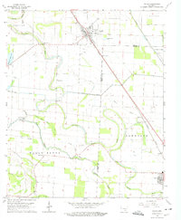
Editions of this 1964 Gould Map
2 editions found
Other maps of this area

1935 · Varner
USGS Topo · 1:62,500

1935 · Rotan
USGS Topo · 1:62,500

1935 · Red Fork
USGS Topo · 1:62,500

1935 · Gillett
USGS Topo · 1:62,500

1948 · Helena
USGS Topo · 1:250,000

1950 · Helena
USGS Topo · 1:250,000

1953 · Greenwood
USGS Topo · 1:250,000

1955 · Helena
USGS Topo · 1:250,000

1956 · Greenwood
USGS Topo · 1:250,000

1959 · Helena
USGS Topo · 1:250,000