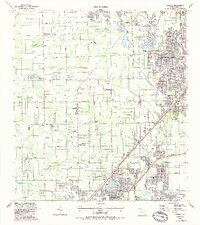
1988 Map of Goulds
USGS Topo · Published 1988About this map
Homestead A F Base and the expansive Metrozoo grounds anchor this portrait of southern Dade County, reflecting a landscape defined by institutional presence and leisure attractions. The residential and agricultural fabric of Goulds, Princeton, and Naranja follows the corridor of the Seaboard System railroad and the South Dixie Highway, showing the region's historical reliance on these transport arteries. Local history is deeply embedded in the layout of sites like Aladdin City, the Gold Coast R R Museum, and Monkey Jungle. Smaller landmarks such as the Lindbergh Landing Strip and the Metropolitan Correctional Center contrast with the community focus of Redland Ch and the numerous schools, including South Dade High Sch and Mays Jr High Sch. The map reveals a transition from suburban development to the hammocks and groves of the Fruit and Spice Park.
Find a feature on this map
65 named features on this map. Tap any name to fly to it.
Don’t see what you’re looking for? This feature index may not catch every label — zoom into the map to look around manually.
Map Details
Editions of this 1988 Goulds Map
This is the sole edition of this map. No revisions or reprints were ever made.
Other maps of this area

1949 · South Miami NW
USGS Topo · 1:24,000

1949 · Arsenicker Keys
USGS Topo · 1:24,000

1949 · Goulds
USGS Topo · 1:24,000

1949 · Perrine
USGS Topo · 1:24,000

1950 · Homestead
USGS Topo · 1:24,000

1950 · South Miami
USGS Topo · 1:24,000

1955 · South Miami NW
USGS Topo · 1:24,000

1956 · Goulds
USGS Topo · 1:24,000

1956 · Perrine
USGS Topo · 1:24,000

1956 · South Miami
USGS Topo · 1:24,000
Featured Places
- Princeton, FL
- Goulds, FL
- Naranja, FL
- Leisure Mobile Home Park-Modello Park, FL
- Pine Isle Mobile Home Park, FL