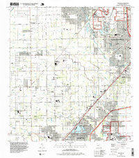
1994 Map of Goulds
USGS Topo · Published 1999About this map
South Miami Heights and Leisure City anchor this 1994 survey of southern Florida, illustrating a landscape defined by an extensive grid of numbered streets and specialized agricultural and institutional sites. The northern reach is dominated by the Metrozoo and the Federal Bureau of Prisons Metropolitan Correctional Center, while the southern end includes the edge of the Homestead A F Base. Historically unique aviation features are scattered throughout, from the Lindbergh Landing Strip to numerous private fields like the Goldstein Landing Strip and Davis Landing Strip. These small airfields, alongside specialized landmarks like the Monkey Jungle and Fruit and Spice Park, reflect the region's mid-century evolution from a rural fruit-growing center to a suburbanized corridor. The map also traces the Dixie Highway and Floridas Turnpike as they pass through the settlements of Goulds, Princeton, and Naranja.
Find a feature on this map
91 named features on this map. Tap any name to fly to it.
Don’t see what you’re looking for? This feature index may not catch every label — zoom into the map to look around manually.
Map Details
Editions of this 1994 Goulds Map
This is the sole edition of this map. No revisions or reprints were ever made.
Other maps of this area

1949 · South Miami NW
USGS Topo · 1:24,000

1949 · Arsenicker Keys
USGS Topo · 1:24,000

1949 · Goulds
USGS Topo · 1:24,000

1949 · Perrine
USGS Topo · 1:24,000

1950 · Homestead
USGS Topo · 1:24,000

1950 · South Miami
USGS Topo · 1:24,000

1955 · South Miami NW
USGS Topo · 1:24,000

1956 · Goulds
USGS Topo · 1:24,000

1956 · Perrine
USGS Topo · 1:24,000

1956 · South Miami
USGS Topo · 1:24,000
Featured Places
- Princeton, FL
- Goulds, FL
- Naranja, FL
- Leisure Mobile Home Park-Modello Park, FL
- Pine Isle Mobile Home Park, FL