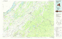
1985 Map of Gouverneur
USGS Topo · Published 1985About this map
Gouverneur serves as the central hub of this 1980s mid-elevation landscape, where the Oswegatchie River winds through a complex network of dairy country and mineral-rich terrain. The map captures a transition from the agricultural lowlands near Black Lake to the rising elevations of the Adirondack Park in the southeast. Significant land use is dedicated to the Fort Drum Military Reservation, which dominates the southern portion of the sheet near Philadelphia and Evans Mills.
Find a feature on this map
286 named features on this map. Tap any name to fly to it.
Don’t see what you’re looking for? This feature index may not catch every label — zoom into the map to look around manually.
Map Details
Editions of this 1985 Gouverneur Map
2 editions found
Other maps of this area

1893 · Sackets Harbor
USGS Topo · 1:62,500

1895 · Sacketts Harbor
USGS Topo · 1:62,500

1895 · Watertown
USGS Topo · 1:62,500

1898 · Watertown
USGS Topo · 1:62,500

1900 · Clayton
USGS Topo · 1:62,500

1902 · Carthage
USGS Topo · 1:62,500

1903 · Big Moose
USGS Topo · 1:62,500

1903 · Grindstone
USGS Topo · 1:62,500

1903 · Clayton
USGS Topo · 1:62,500

1903 · Alexandria Bay
USGS Topo · 1:62,500