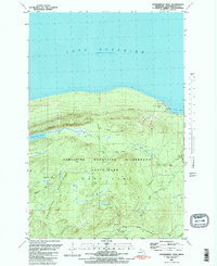
1981 Map of Government Peak
USGS Topo · Published 1981About this map
Porcupine Mountains Wilderness State Park dominates this 1981 survey, revealing a landscape defined by dramatic topography and a legacy of copper exploration. The inland heights of Government Peak and Cuyahoga Peak rise sharply from the shoreline of Lake Superior, providing the backdrop for the notable Cloud Peak Escarpment. Natural water features like the perched Lake of the Clouds and the cascading Trap Falls are central to the terrain, while the Union River and Carp River drain the high country toward Union Bay.
Find a feature on this map
34 named features on this map. Tap any name to fly to it.
Don’t see what you’re looking for? This feature index may not catch every label — zoom into the map to look around manually.
Map Details
Editions of this 1981 Government Peak Map
2 editions found
Other maps of this area

1949 · White Pine
USGS Topo · 1:24,000

1949 · Bergland NE
USGS Topo · 1:24,000

1956 · Carp River
USGS Topo · 1:62,500

1956 · Bergland NE
USGS Topo · 1:24,000

1956 · Bergland
USGS Topo · 1:62,500

1956 · Thomaston
USGS Topo · 1:62,500

1956 · White Pine
USGS Topo · 1:24,000

1956 · White Pine
USGS Topo · 1:62,500

1958 · Iron River
USGS Topo · 1:250,000

1960 · Iron River
USGS Topo · 1:250,000