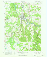
1963 Map of Gowanda
USGS Topo · Published 1973About this map
Cattaraugus Creek carves a deep path through this landscape, marking the boundary between Erie and Cattaraugus counties. The village of Gowanda serves as a central hub, where the Erie-Lackawanna railroad lines converge near the Gowanda State Hospital and Central High Sch. This era of the early 1960s shows a region defined by its institutions and its geography, from the Cattaraugus Indian Reservation in the north to the dramatic descent into Zoar Valley in the southeast.
Find a feature on this map
76 named features on this map. Tap any name to fly to it.
Don’t see what you’re looking for? This feature index may not catch every label — zoom into the map to look around manually.
Map Details
Editions of this 1963 Gowanda Map
2 editions found
Other maps of this area

1899 · Silver Creek
USGS Topo · 1:62,500

1900 · Cherry Creek
USGS Topo · 1:62,500

1905 · Eden
USGS Topo · 1:62,500

1907 · Eden
USGS Topo · 1:62,500

1923 · Cattaraugus
USGS Topo · 1:62,500

1938 · Cattaraugus
USGS Topo · 1:62,500

1941 · Cattaraugus
USGS Topo · 1:62,500

1941 · Cherry Creek
USGS Topo · 1:62,500

1944 · Eden
USGS Topo · 1:62,500

1944 · North Collins
USGS Topo · 1:31,680