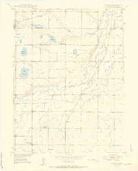
1950 Map of Gowanda
USGS Topo · Published 1950About this map
St Vrain Creek meanders through the heart of Weld County, defining a landscape of intensive early-twentieth-century irrigation and agricultural development. This 1949 survey documents a complex network of water management, including the Chance Ditch, Last Chance Ditch, and Lupton Bottom Ditch, which fed the surrounding sugar beet and grain fields. The presence of the Great Western and Union Pacific railroads highlights the region's industrial connection to the wider Colorado economy, facilitating the movement of crops from small sidings like Gowanda and Harney. Local social life is anchored by the Rinn Community Church and the Rinn Valley Grange, while the education system of the era is represented by the Stone School, Dailey School, and the already Pearl Howlett School (Aban'd). This map captures the rural character of the area before modern suburban expansion transformed the corridor between Denver and Loveland.
Find a feature on this map
30 named features on this map. Tap any name to fly to it.
Don’t see what you’re looking for? This feature index may not catch every label — zoom into the map to look around manually.
Map Details
Editions of this 1950 Gowanda Map
2 editions found
Other maps of this area

1902 · Greeley
USGS Topo · 1:125,000

1904 · Niwot
USGS Topo · 1:62,500

1906 · Loveland
USGS Topo · 1:62,500

1908 · Loveland
USGS Topo · 1:62,500

1949 · Gowanda
USGS Topo · 1:24,000

1949 · Fort Lupton
USGS Topo · 1:24,000

1949 · Platteville
USGS Topo · 1:24,000

1950 · Frederick
USGS Topo · 1:24,000

1950 · Gowanda
USGS Topo · 1:24,000

1950 · Platteville
USGS Topo · 1:24,000