1977 Map of Gowen
USGS Topo · Published 1977About this map
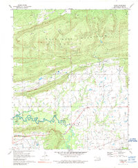
The Sans Bois Mountains dominate the northern landscape of this orthophotoquad, rising above a series of small rural communities. The 1977 aerial imagery reveals a distinct transition from the high, wooded ridges to the meandering drainage patterns of Gaines Creek in the south. Several small settlements, including Gowen and Bowers, are visible as clusters of structures and cleared land amidst the complex terrain. The map's photographic nature provides a direct look at land usage, showing the cleared pastures and narrow wooded corridors that defined this part of Latimer County. To the west, the community of Drumb and the central settlement of Chilli are connected by a network of local roads, while Patterson occupies the northeastern reaches of the valley. The imagery also traces the course of Ash Creek as it cuts through the northern hills.
Find a feature on this map
8 named features on this map. Tap any name to fly to it.
Don’t see what you’re looking for? This feature index may not catch every label — zoom into the map to look around manually.
Map Details
Editions of this 1977 Gowen Map
This is the sole edition of this map. No revisions or reprints were ever made.