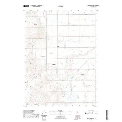
2020 Map of Grace Power Plant
USGS Topo · Published 2020About this map
The Grace Power Plant stands as a focal point in this Caribou County landscape, situated where the Bear River enters the dramatic Black Canyon. This region is defined by a sophisticated network of water management, including the Gentile Valley Canal, N Extension Canal, and Tanner Canal, which support the agricultural life of Gentile Valley and the settlement of Turner. To the west, the terrain rises sharply into the Fish Creek Range and Buckskin Mtn, creating a stark contrast between the irrigated valley floor and the high country. Genealogists and local historians can trace family-named landmarks like China Hill and Cedar Hollow, or locate specific sites such as Kockley Spring and the Turner Cemetery Rd. The map illustrates the 21st-century configuration of rural roads and water rights that have shaped this portion of Idaho for generations.
Find a feature on this map
54 named features on this map. Tap any name to fly to it.
Don’t see what you’re looking for? This feature index may not catch every label — zoom into the map to look around manually.
Map Details
Editions of this 2020 Grace Power Plant Map
This is the sole edition of this map. No revisions or reprints were ever made.
Other maps of this area

1915 · Preston
USGS Topo · 1:96,000

1918 · Preston
USGS Topo · 1:125,000

1948 · Bancroft
USGS Topo · 1:62,500

1948 · Soda Springs
USGS Topo · 1:62,500

1949 · Bancroft
USGS Topo · 1:62,500

1949 · Soda Springs
USGS Topo · 1:62,500

1955 · Preston
USGS Topo · 1:250,000

1958 · Preston
USGS Topo · 1:250,000

1962 · Preston
USGS Topo · 1:250,000
1969 · Cottonwood Peak
USGS Topo · 1:24,000