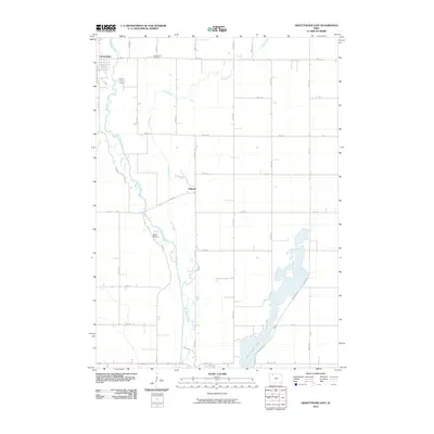
2010 Map of Graettinger East
USGS Topo · Published 2010About this map
The Des Moines River winds through the western edge of this Palo Alto County landscape, defining the local topography alongside the meandering path of Jack Creek. This area of northern Iowa is characterized by a precise grid of rural roads and the presence of small, established settlements. Graettinger occupies the northwest corner, while the smaller community of Osgood and the locality of Black Walnut are situated further south along the river valley. The southern portion of the map is dominated by the northern reaches of Five Island Lake, a significant water body that influences the surrounding road network, including N Huron Rd and College Dr. Local genealogy and history are anchored at the Valley View Cemetery, located north of the creek, providing a clear spatial record of the township's development and its connection to the river-fed environment.
Find a feature on this map
28 named features on this map. Tap any name to fly to it.
Don’t see what you’re looking for? This feature index may not catch every label — zoom into the map to look around manually.
Map Details
Editions of this 2010 Graettinger East Map
This is the sole edition of this map. No revisions or reprints were ever made.
Other maps of this area

1954 · Fairmont
USGS Topo · 1:250,000

1958 · Fairmont
USGS Topo · 1:250,000

1972 · Graettinger West
USGS Topo · 1:24,000

1972 · Wallingford
USGS Topo · 1:24,000

1972 · Ayrshire
USGS Topo · 1:24,000

1980 · Depew
USGS Topo · 1:24,000

1980 · Ringsted
USGS Topo · 1:24,000

1980 · Ingham Lake
USGS Topo · 1:24,000

1980 · Graettinger East
USGS Topo · 1:24,000
1980 · Emmetsburg
USGS Topo · 1:24,000