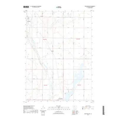
2018 Map of Graettinger East
USGS Topo · Published 2018About this map
The Des Moines River winds through the heart of Palo Alto County, defining a landscape of agricultural sections and riparian wetlands in this 2018 survey. The northern reaches of Emmetsburg appear at the southern edge of the map, while the small community of Osgood and the eastern portion of Graettinger anchor the northern sections. The map reveals a highly structured drainage system, notably Ditch Number 132, which supports the productivity of the surrounding farmland. Genealogy and local history researchers will find Valley View Cem situated near the intersection of Co Hwy N40 and 280th St, north of where Jack Cr joins the larger river system. The presence of River Rd tracking the watercourse suggests long-standing travel corridors that predate the modern township grid.
Find a feature on this map
40 named features on this map. Tap any name to fly to it.
Don’t see what you’re looking for? This feature index may not catch every label — zoom into the map to look around manually.
Map Details
Editions of this 2018 Graettinger East Map
This is the sole edition of this map. No revisions or reprints were ever made.
Other maps of this area

1954 · Fairmont
USGS Topo · 1:250,000

1958 · Fairmont
USGS Topo · 1:250,000

1972 · Graettinger West
USGS Topo · 1:24,000

1972 · Wallingford
USGS Topo · 1:24,000

1972 · Ayrshire
USGS Topo · 1:24,000

1980 · Depew
USGS Topo · 1:24,000

1980 · Ringsted
USGS Topo · 1:24,000

1980 · Ingham Lake
USGS Topo · 1:24,000

1980 · Graettinger East
USGS Topo · 1:24,000
1980 · Emmetsburg
USGS Topo · 1:24,000