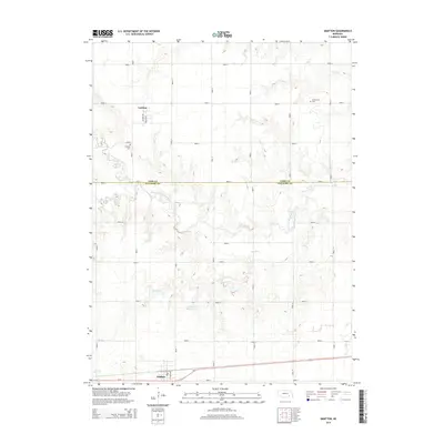
2014 Map of Grafton
USGS Topo · Published 2014About this map
Grafton sits along the southern edge of this landscape, positioned along Us-6 and defined by a rigid grid of agricultural roads that span the border of York and Fillmore Counties. The terrain is characterized by the meandering drainage systems of the West Fork Big Blue River and its tributaries, including Elk Run and School Cr. In the northern section, the small settlement of Lushton remains a focal point of the local geography, surrounded by extensive fields. Local history and genealogy are anchored by landmarks such as Greenwood Cem and Lushton Cem, while water management is evidenced by the presence of Stuckey Reservoir. The map illustrates a contemporary rural environment where historical settlement patterns persist through these established towns and cemeteries amidst a highly organized section-line road network.
Find a feature on this map
37 named features on this map. Tap any name to fly to it.
Don’t see what you’re looking for? This feature index may not catch every label — zoom into the map to look around manually.
Map Details
Editions of this 2014 Grafton Map
This is the sole edition of this map. No revisions or reprints were ever made.
Other maps of this area

1898 · York
USGS Topo · 1:125,000

1899 · York
USGS Topo · 1:125,000

1955 · Lincoln
USGS Topo · 1:250,000

1957 · Lincoln
USGS Topo · 1:250,000

1958 · Lincoln
USGS Topo · 1:250,000
1968 · Henderson
USGS Topo · 1:24,000

1969 · Bixby
USGS Topo · 1:24,000
1969 · Geneva
USGS Topo · 1:24,000

1969 · Fairmont
USGS Topo · 1:24,000
1969 · Grafton
USGS Topo · 1:24,000