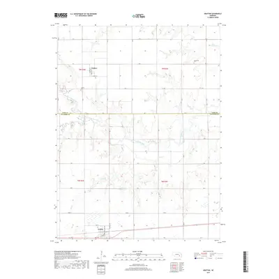
2017 Map of Grafton
USGS Topo · Published 2017About this map
Grafton anchors the southern portion of this agricultural landscape in Fillmore County, where the local grid is defined by a dense network of country roads including Road E and RD F. The village layout is detailed down to streets such as Omaha St and South St. Moving north across the county line into York County, the small community of Lushton appears along Lushton Rd, surrounded by productive farmland and rural landmarks like the Lushton Cem. The region's hydrology is dominated by the meandering W Fork Big Blue River and several smaller tributaries such as Stone Cr and Elk Run. For local historians and genealogists, the map identifies specific interment sites like Greenwood Cem and documents water management features such as the Stuckey Reservoir.
Find a feature on this map
30 named features on this map. Tap any name to fly to it.
Don’t see what you’re looking for? This feature index may not catch every label — zoom into the map to look around manually.
Map Details
Editions of this 2017 Grafton Map
This is the sole edition of this map. No revisions or reprints were ever made.
Other maps of this area

1898 · York
USGS Topo · 1:125,000

1899 · York
USGS Topo · 1:125,000

1955 · Lincoln
USGS Topo · 1:250,000

1957 · Lincoln
USGS Topo · 1:250,000

1958 · Lincoln
USGS Topo · 1:250,000
1968 · Henderson
USGS Topo · 1:24,000

1969 · Bixby
USGS Topo · 1:24,000
1969 · Geneva
USGS Topo · 1:24,000

1969 · Fairmont
USGS Topo · 1:24,000
1969 · Grafton
USGS Topo · 1:24,000