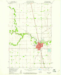
1960 Map of Grafton
USGS Topo · Published 1961About this map
The Grafton city center serves as a dense municipal hub on this Walsh County survey, where the confluence of the Great Northern and Northern Pacific railroads dictates the local economy and layout. Significant institutional landmarks dominate the western and central parts of town, including the sprawling grounds of the State Sch, as well as Deaconess Hospital and St Joseph Hospital. The Park River meanders through the landscape, fed by its North Branch, Middle Branch, and South Branch, providing a green corridor that includes Leistikow Memorial Park. Beyond the city limits, the land transitions into the geometric precision of the Farmington, Martin, and Oakwood townships. This 1960s view documents a well-established prairie community, from its civic infrastructure like the Chase Sch and Central Sch to the Radio Tower (KGPC) standing in the open fields to the southwest.
Find a feature on this map
29 named features on this map. Tap any name to fly to it.
Don’t see what you’re looking for? This feature index may not catch every label — zoom into the map to look around manually.
Map Details
Editions of this 1960 Grafton Map
This is the sole edition of this map. No revisions or reprints were ever made.
Other maps of this area

1939 · Glasston
USGS Topo · 1:62,500

1941 · Glasston
USGS Topo · 1:62,500
1943 · Grafton
USGS Topo · 1:62,500
1944 · Crystal
USGS Topo · 1:62,500

1952 · Thief River Falls
USGS Topo · 1:250,000

1956 · Thief River Falls
USGS Topo · 1:250,000

1957 · Thief River Falls
USGS Topo · 1:250,000
1960 · Oakwood
USGS Topo · 1:24,000
1963 · Crystal SE
USGS Topo · 1:24,000
1963 · Veseleyville
USGS Topo · 1:24,000