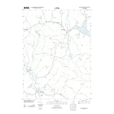
2013 Map of Grahamsville
USGS Topo · Published 2013About this map
The Roundout Reservoir dominates the northeastern corner of this Sullivan County landscape, serving as a critical piece of regional water infrastructure alongside the subsurface Neversink Roundout Aqueduct. In this 2013 snapshot of the Catskill foothills, the settlement of Grahamsville stands at the junction of Chestnut Cr and the reservoir's western reaches, while the village of Woodbourne anchors the southwest near the Woodbourne Correctional Institute. The terrain is defined by prominent elevations such as Thunder Hill and South Hill, with various brooks like Wynkoop Brook and Beer Kill draining the upland valleys. Local history is etched into the map through features like the Rural Cem near Grahamsville and several small agricultural and residential nodes including Curry, Unionville, and Hasbrouck.
Find a feature on this map
121 named features on this map. Tap any name to fly to it.
Don’t see what you’re looking for? This feature index may not catch every label — zoom into the map to look around manually.
Map Details
Editions of this 2013 Grahamsville Map
This is the sole edition of this map. No revisions or reprints were ever made.
Other maps of this area

1903 · Slide Mountain
USGS Topo · 1:62,500

1904 · Ellenville
USGS Topo · 1:62,500

1905 · Slide Mountain
USGS Topo · 1:62,500

1906 · Ellenville
USGS Topo · 1:62,500

1909 · Monticello
USGS Topo · 1:62,500

1910 · Neversink
USGS Topo · 1:62,500

1911 · Monticello
USGS Topo · 1:62,500

1942 · Neversink
USGS Topo · 1:62,500

1942 · Lackawack
USGS Topo · 1:24,000
1942 · Ellenville
USGS Topo · 1:24,000