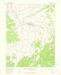
1957 Map of Granby
USGS Topo · Published 1959About this map
Granby sits at the confluence of the Colorado River and the Fraser River, serving as a vital ranching and transportation hub in the late 1950s. The Denver and Rio Grande Western railroad tracks parallel the winding river courses, anchoring the local economy alongside timber interests represented by a sawmill. To the south, the Arapaho National Forest boundary marks a shift toward public lands, where the Tabernash Campground and Camp Chief Ouray (YMCA) indicate early mid-century recreational development. Water management is a defining characteristic of this landscape, with the Highline Ditch and Peterson Ditch redirecting flows across the valley. Rural life is evidenced by the Eightmile Sch (Aband), a poignant marker of shifting settlement patterns as smaller schoolhouses were consolidated or left behind during the post-war era.
Find a feature on this map
35 named features on this map. Tap any name to fly to it.
Don’t see what you’re looking for? This feature index may not catch every label — zoom into the map to look around manually.
Map Details
Editions of this 1957 Granby Map
4 editions found
Other maps of this area

1915 · Longs Peak
USGS Topo · 1:125,000

1919 · Rocky Mountain National Park
USGS Topo · 1:125,000

1924 · Fraser
USGS Topo · 1:62,500

1926 · Fraser
USGS Topo · 1:62,500

1933 · Ute Peak
USGS Topo · 1:62,500

1937 · Ute Peak
USGS Topo · 1:62,500

1953 · Denver
USGS Topo · 1:250,000

1954 · Greeley
USGS Topo · 1:250,000

1954 · Craig
USGS Topo · 1:250,000

1957 · Denver
USGS Topo · 1:250,000