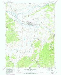
1957 Map of Granby
USGS Topo · Published 1978About this map
The confluence of the Colorado River and the Fraser River anchors this mid-century topographic study of Grand County. The town of Granby is shown as a central hub for transportation and water management, situated along the Denver and Rio Grande Western railroad. The landscape is defined by its complex irrigation infrastructure, featuring the Bunte High Line Ditch and Peterson Ditch, which trace the contours of Granby Mesa.
Find a feature on this map
37 named features on this map. Tap any name to fly to it.
Don’t see what you’re looking for? This feature index may not catch every label — zoom into the map to look around manually.
Map Details
Editions of this 1957 Granby Map
4 editions found
Other maps of this area

1915 · Longs Peak
USGS Topo · 1:125,000

1919 · Rocky Mountain National Park
USGS Topo · 1:125,000

1924 · Fraser
USGS Topo · 1:62,500

1926 · Fraser
USGS Topo · 1:62,500

1933 · Ute Peak
USGS Topo · 1:62,500

1937 · Ute Peak
USGS Topo · 1:62,500

1953 · Denver
USGS Topo · 1:250,000

1954 · Greeley
USGS Topo · 1:250,000

1954 · Craig
USGS Topo · 1:250,000

1957 · Denver
USGS Topo · 1:250,000