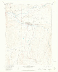
1957 Map of Granby
USGS Topo · Published 1963About this map
Granby stands at the confluence of the Fraser River and the Colorado River, serving as a central hub for ranching and transportation during the mid-century. This survey captures the town when its economy was tied to the Denver and Rio Grande Western railroad and local timber processing, evidenced by a Sawmill and nearby Gravel Pit. To the south, the landscape transitions into the Arapaho National Forest, where a network of drainage basins including Eightmile Creek and Ninemile Creek defines the terrain. Notable for local historians is the Eightmile Sch (Aband), a relic of earlier rural settlement patterns. The map also documents recreational and community landmarks such as the Camp Chief Ouray (YMCA), the Airport, and the Rodeo Grounds, illustrating the area's development as a mountain destination.
Find a feature on this map
35 named features on this map. Tap any name to fly to it.
Don’t see what you’re looking for? This feature index may not catch every label — zoom into the map to look around manually.
Map Details
Editions of this 1957 Granby Map
4 editions found
Other maps of this area

1915 · Longs Peak
USGS Topo · 1:125,000

1919 · Rocky Mountain National Park
USGS Topo · 1:125,000

1924 · Fraser
USGS Topo · 1:62,500

1926 · Fraser
USGS Topo · 1:62,500

1933 · Ute Peak
USGS Topo · 1:62,500

1937 · Ute Peak
USGS Topo · 1:62,500

1953 · Denver
USGS Topo · 1:250,000

1954 · Greeley
USGS Topo · 1:250,000

1954 · Craig
USGS Topo · 1:250,000

1957 · Denver
USGS Topo · 1:250,000