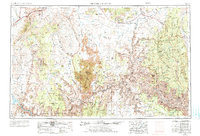
1953 Map of Grand Canyon
USGS Topo · Published 1973About this map
Grand Canyon and its surrounding plateaus are documented here during a period of mid-century revision, reflecting the complex topography between the Colorado River and the high desert rim. The map reveals a landscape defined by dramatic geological breaks, including the Shinarump Cliffs and Vermilion Cliffs, alongside the early infrastructure of the Pipe Spring National Monument. Remote settlements such as Fredonia and Moccasin appear as isolated outposts against the expanse of the Kaibab Plateau.
Find a feature on this map
76 named features on this map. Tap any name to fly to it.
Don’t see what you’re looking for? This feature index may not catch every label — zoom into the map to look around manually.
Map Details
Editions of this 1953 Grand Canyon Map
3 editions found

Other maps of this area

1885 · St. George
USGS Topo · 1:250,000

1885 · Pioche
USGS Topo · 1:250,000

1886 · Diamond Creek
USGS Topo · 1:250,000

1886 · Camp Mohave
USGS Topo · 1:250,000

1886 · Kanab
USGS Topo · 1:250,000

1886 · Escalante
USGS Topo · 1:250,000

1886 · Saint Thomas
USGS Topo · 1:250,000

1886 · San Francisco Mtns
USGS Topo · 1:250,000

1886 · Mt. Trumbull
USGS Topo · 1:250,000

1886 · Chino
USGS Topo · 1:250,000