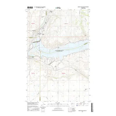
2017 Map of Grand Coulee Dam
USGS Topo · Published 2017About this map
The Grand Coulee Dam dominates this geography, anchoring the massive impoundment of the Columbia River to form Franklin D Roosevelt Lake. This modern survey illustrates the complex intersection of the dam's infrastructure with the neighboring communities of Coulee Dam, Grand Coulee, and Mason City. The surrounding landscape is characterized by high plateau features like Washington Flats and Sand Hill, while the reservoir's shoreline creates recreational landmarks within the Lake Roosevelt National Recreation Area, including Gibbs Bay and Crescent Bay.
Find a feature on this map
72 named features on this map. Tap any name to fly to it.
Don’t see what you’re looking for? This feature index may not catch every label — zoom into the map to look around manually.
Map Details
Editions of this 2017 Grand Coulee Dam Map
This is the sole edition of this map. No revisions or reprints were ever made.
Other maps of this area

1948 · Grand Coulee Dam
USGS Topo · 1:62,500

1950 · Grand Coulee Dam
USGS Topo · 1:62,500

1950 · Nespelem
USGS Topo · 1:62,500

1950 · Alameda Flat
USGS Topo · 1:62,500

1952 · Alameda Flat
USGS Topo · 1:62,500

1953 · Ritzville
USGS Topo · 1:250,000

1954 · Okanogan
USGS Topo · 1:250,000

1958 · Okanogan
USGS Topo · 1:250,000

1959 · Ritzville
USGS Topo · 1:250,000

1965 · Ritzville
USGS Topo · 1:250,000