
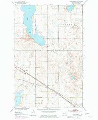
1951 Map of Grand Harbor
USGS Topo · Published 1951About this map
Grand Harbor and the adjacent settlement of Darby anchor this early 1950s survey of the Ramsey County prairie. The landscape is defined by its transition from the expansive Dry Lake in the west to the wetlands and potholes of Freshwater Lake and Cavanaugh Lake to the northeast. Transportation is dominated by the intersecting routes of the Great Northern and the Minneapolis St Paul and Sault Ste Marie railroads, which cross the southern portion of the quadrangle. Local civic life is represented by School No 1 and the Grand Harbor Cem, while the southern margin reaches the shores of Devils Lake at Sixmile Bay. This map documents a period before major hydrological changes and modern road expansions altered the drainage patterns of this lake-studded region.
Find a feature on this map
14 named features on this map. Tap any name to fly to it.
Don’t see what you’re looking for? This feature index may not catch every label — zoom into the map to look around manually.
Map Details
Editions of this 1951 Grand Harbor Map
2 editions found
Other maps of this area

1931 · Devils Lake
USGS Topo · 1:62,500

1932 · Grahams Island
USGS Topo · 1:62,500

1950 · Grahams Island
USGS Topo · 1:62,500

1950 · Devils Lake
USGS Topo · 1:62,500

1951 · Devils Lake
USGS Topo · 1:24,000

1951 · Grahams Island
USGS Topo · 1:24,000

1951 · Camp Grafton
USGS Topo · 1:24,000

1951 · Penn
USGS Topo · 1:24,000

1951 · Sweetwater
USGS Topo · 1:24,000

1953 · Devils Lake
USGS Topo · 1:250,000