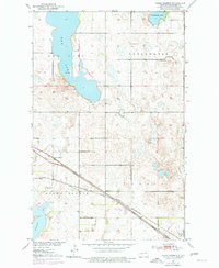
1951 Map of Grand Harbor
USGS Topo · Published 1977About this map
The Great Northern and the Minneapolis St Paul and Sault Ste Marie railroads converge near the northern shores of Devils Lake, defining the local transit corridor of mid-century Ramsey County. The landscape is dominated by the complex hydrology of the prairie pothole region, characterized by large water bodies like Dry Lake, Cavanaugh Lake, and Freshwater Lake. The small settlement of Grand Harbor serves as a local hub, supported by the nearby Darby siding. Local infrastructure from the early 1950s is meticulously recorded, including School No 1, the Grand Harbor Cem, and a Gravel Pit. The mapping reveals the transition from the upland basins to the recessed waters of Six Mile Bay, illustrating the area's historical reliance on rail connectivity and its distinct glacial topography.
Find a feature on this map
14 named features on this map. Tap any name to fly to it.
Don’t see what you’re looking for? This feature index may not catch every label — zoom into the map to look around manually.
Map Details
Editions of this 1951 Grand Harbor Map
2 editions found
Other maps of this area

1931 · Devils Lake
USGS Topo · 1:62,500

1932 · Grahams Island
USGS Topo · 1:62,500

1950 · Grahams Island
USGS Topo · 1:62,500

1950 · Devils Lake
USGS Topo · 1:62,500

1951 · Devils Lake
USGS Topo · 1:24,000

1951 · Grahams Island
USGS Topo · 1:24,000

1951 · Grand Harbor
USGS Topo · 1:24,000

1951 · Camp Grafton
USGS Topo · 1:24,000

1951 · Penn
USGS Topo · 1:24,000

1951 · Sweetwater
USGS Topo · 1:24,000