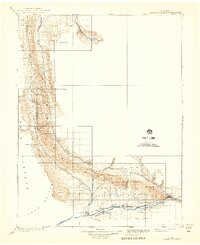
1910 Map of Grand Hogback
USGS Topo · Published 1941About this map
The Grand Hogback dominates this 1906 topographic survey, forming a sharp, continuous ridge that dictates the settlement and transit patterns of Western Colorado at the turn of the century. Along the southern corridor, the Colorado River valley serves as the primary artery for both the Denver and Rio Grande River railroad and a string of burgeoning towns including Rifle, Silt, and Newcastle. This industrial and agricultural ribbon contrasts with the high, arid ranching country to the north and west.
Find a feature on this map
26 named features on this map. Tap any name to fly to it.
Don’t see what you’re looking for? This feature index may not catch every label — zoom into the map to look around manually.
Map Details
Editions of this 1910 Grand Hogback Map
3 editions found
Other maps of this area

1906 · Grand Hogback
USGS Topo · 1:125,000

1907 · White River
USGS Topo · 1:125,000

1910 · Danforth Hills
USGS Topo · 1:125,000

1910 · Grand Hogback
USGS Topo · 1:125,000

1910 · White River
USGS Topo · 1:125,000

1912 · Meeker
USGS Topo · 1:62,500

1914 · Meeker
USGS Topo · 1:62,500

1925 · Parachute Creek
USGS Topo · 1:62,500

1927 · Parachute Creek
USGS Topo · 1:62,500

1927 · Glenwood Springs
USGS Topo · 1:125,000