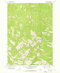
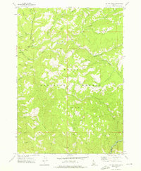
1972 Map of Grand Mtn
USGS Topo · Published 1976About this map
The Middle Fork Boise River and the main stem of the Boise River converge within the Boise National Forest in this 1970s topographic study. The landscape is defined by the steep drainage basins of Roaring River and Frank Creek, where the narrow river valleys provided essential corridors for movement. A Spring (Hot) near the river indicates the geothermal activity characteristic of the Sawtooth wilderness area. Evidence of early wilderness travel is preserved in the network of trails and pack trails that lace the high ridges between Grand Mtn and Granite Mtn. These routes followed natural topographical breaks such as Beaver Creek and Wren Creek, providing access to the remote backcountry before more modern infrastructure reached the interior of Elmore County.
Find a feature on this map
25 named features on this map. Tap any name to fly to it.
Don’t see what you’re looking for? This feature index may not catch every label — zoom into the map to look around manually.
Map Details
Editions of this 1972 Grand Mtn Map
2 editions found
Other maps of this area

1894 · Idaho Basin
USGS Topo · 1:125,000

1894 · Rocky Bar
USGS Topo · 1:125,000

1955 · Hailey
USGS Topo · 1:250,000

1959 · Hailey
USGS Topo · 1:250,000

1962 · Hailey
USGS Topo · 1:250,000

1964 · Little Trinity Lake
USGS Topo · 1:24,000

1964 · Sheep Creek
USGS Topo · 1:24,000
1964 · Rocky Bar
USGS Topo · 1:24,000
1972 · Barber Flat
USGS Topo · 1:24,000
1972 · Big Owl Creek
USGS Topo · 1:24,000