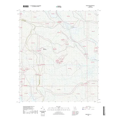
2020 Map of Grand River
USGS Topo · Published 2020About this map
The Atchafalaya Basin Floodway dominates this landscape, defining a complex network of waterways where Iberville Parish and ST Martin Parish meet. The Grand River and Upper Grand River serve as central arteries for this wetland environment, which is intricately carved by numerous distributaries including Bayou Pigeon, Bayou Maringouin, and Bayou Sorrel. The lack of dense road infrastructure, save for the presence of Bayou Sorrell Rd, highlights the region's historical reliance on water-based travel and its role as a massive natural spillway. Interior water bodies like Pigeon Bay, Spike Bay, and Frog Lake dot the swampy terrain, illustrating the hydrologic complexity of the basin. The map preserves the exact boundaries and drainage patterns of these bayous and coves, such as Sawyers Cove and Tarleton Bayou, providing an essential reference for understanding the geography of southern Louisiana's river country.
Find a feature on this map
33 named features on this map. Tap any name to fly to it.
Don’t see what you’re looking for? This feature index may not catch every label — zoom into the map to look around manually.
Map Details
Editions of this 2020 Grand River Map
This is the sole edition of this map. No revisions or reprints were ever made.
Other maps of this area

1935 · Osca Bayou
USGS Topo · 1:62,500

1935 · Chicot Lake
USGS Topo · 1:62,500

1940 · Grosse Tete
USGS Topo · 1:62,500

1941 · Loreauville
USGS Topo · 1:62,500

1953 · Crescent
USGS Topo · 1:24,000

1953 · Cow Bayou
USGS Topo · 1:24,000

1953 · Pigeon Bay
USGS Topo · 1:24,000

1953 · Addis
USGS Topo · 1:24,000

1953 · Grosse Tete SW
USGS Topo · 1:24,000

1954 · Chicot Lake
USGS Topo · 1:62,500