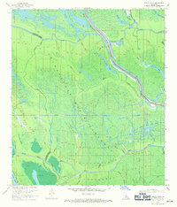
1969 Map of Grand River
USGS Topo · Published 1971About this map
The Atchafalaya Basin Floodway dominates this mid-century landscape, illustrating the complex hydrological management of Iberville Parish and ST Martin Parish. At the heart of the swampy terrain, the East Protection Levee stands as a critical barrier, separating the main spillway from the industrial developments of the Bayou Sorrel Oil and Gas Field. This era of the basin was defined by a massive network of natural bayous and man-made interventions, where old waterways like Bayou Maringouin and Bayou Pigeon intersect with the Superior Canal and various Pipeline Canals. Numerous drill holes and gaging stations scattered across the Upper Grand River reflect a period of intensive resource extraction and water level monitoring. Features such as Graveyard Bayou and Berry Lake highlight the remote and primitive character of the basin before more modern infrastructure fully reshaped the region's topography.
Find a feature on this map
44 named features on this map. Tap any name to fly to it.
Don’t see what you’re looking for? This feature index may not catch every label — zoom into the map to look around manually.
Map Details
Editions of this 1969 Grand River Map
3 editions found
Other maps of this area

1935 · Osca Bayou
USGS Topo · 1:62,500

1935 · Chicot Lake
USGS Topo · 1:62,500

1940 · Grosse Tete
USGS Topo · 1:62,500

1941 · Loreauville
USGS Topo · 1:62,500

1953 · Crescent
USGS Topo · 1:24,000

1953 · Cow Bayou
USGS Topo · 1:24,000

1953 · Pigeon Bay
USGS Topo · 1:24,000

1953 · Addis
USGS Topo · 1:24,000

1953 · Grosse Tete SW
USGS Topo · 1:24,000

1954 · Chicot Lake
USGS Topo · 1:62,500