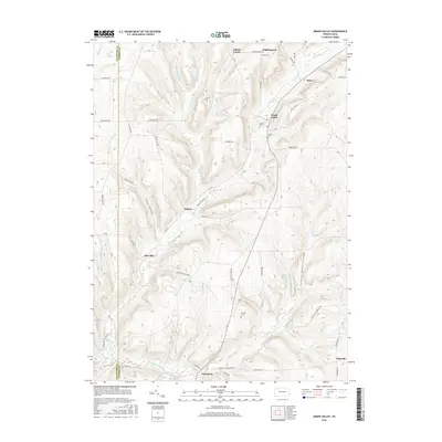
2016 Map of Grand Valley
USGS Topo · Published 2016About this map
Grand Valley and its surrounding rural hamlets are detailed in this study of the border between Crawford and Warren counties. The landscape is defined by the dendritic drainage patterns of Caldwell Cr and Pine Creek, which carve through prominent rises such as Chappel Hill and Emerson Hill. Small settlements like Selkirk, Dotyville, and Enterprise are connected by a network of established local routes, including Tidioute Enterprise Rd and Old Rir Grande. Genealogical interest is found in well-marked burial sites such as Naultby Cem and Loomis Cem near the central valley, and Cheney Cem further south. The map illustrates a contemporary rural Pennsylvania environment where remote terrain features like Stony Hollow and Seldom Seen Hollow persist alongside scattered agricultural and residential outposts.
Find a feature on this map
58 named features on this map. Tap any name to fly to it.
Don’t see what you’re looking for? This feature index may not catch every label — zoom into the map to look around manually.
Map Details
Editions of this 2016 Grand Valley Map
This is the sole edition of this map. No revisions or reprints were ever made.
Other maps of this area
1926 · Youngsville
USGS Topo · 1:62,500
1927 · Tidioute
USGS Topo · 1:48,000
1927 · Titusville
USGS Topo · 1:62,500
1929 · Corry
USGS Topo · 1:48,000
1929 · Youngsville
USGS Topo · 1:62,500
1930 · Tidioute
USGS Topo · 1:62,500
1932 · Corry
USGS Topo · 1:62,500
1933 · Titusville
USGS Topo · 1:62,500
1943 · Youngsville
USGS Topo · 1:62,500
1957 · Warren
USGS Topo · 1:250,000