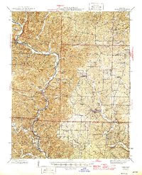
1946 Map of Grandin
USGS Topo · Published 1946About this map
The Current River snakes through the heart of the Ozarks in this mid-century survey, defining a landscape shaped by rugged timberland and mineral extraction. This period in Missouri's history shows the transition of the region from an active mining center, evidenced by the Old Iron Mines, toward a focus on conservation and recreation with the establishment of Big Spring State Park. Along the riverbanks, family-named sites like the McDowell Place and Old Short Place reflect a generation of river-bottom farming, while the uplands are dotted with rural social centers including Bradford Chapel and the Crosswhite Club. Local education is anchored by numerous country schools such as Aldrich Valley Sch and Oak Grove Sch, which served the scattered timber and farming communities of Grandin, Hunter, and Ellsinore before widespread school consolidation changed the rural social fabric of Carter County.
Find a feature on this map
96 named features on this map. Tap any name to fly to it.
Don’t see what you’re looking for? This feature index may not catch every label — zoom into the map to look around manually.
Map Details
Editions of this 1946 Grandin Map
2 editions found

Other maps of this area

1928 · Cardareva
USGS Topo · 1:62,500

1932 · Piedmont
USGS Topo · 1:62,500

1934 · Williamsville
USGS Topo · 1:48,000

1935 · Piedmont
USGS Topo · 1:62,500

1935 · Acorn
USGS Topo · 1:62,500

1939 · Doniphan
USGS Topo · 1:62,500

1940 · Williamsville
USGS Topo · 1:62,500

1940 · Naylor
USGS Topo · 1:62,500

1941 · Gatewood
USGS Topo · 1:62,500

1943 · Ellington
USGS Topo · 1:62,500