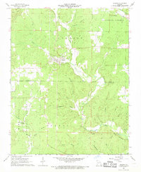
1968 Map of Grandin
USGS Topo · Published 1969About this map
Grandin serves as the primary hub in this late 1960s Ozark landscape, straddling the border of Carter and Ripley Counties. The terrain is defined by the intricate branching of the North Prong and Middle Fork Little Black River, which carve numerous hollows through the Clark National Forest and Mark Twain National Forest. Many of these valleys carry local names such as Greenville Hollow, Coon Hollow, and Barnett Hollow, illustrating a landscape deeply divided by its hydrology.
Find a feature on this map
39 named features on this map. Tap any name to fly to it.
Don’t see what you’re looking for? This feature index may not catch every label — zoom into the map to look around manually.
Map Details
Editions of this 1968 Grandin Map
This is the sole edition of this map. No revisions or reprints were ever made.
Other maps of this area

1934 · Williamsville
USGS Topo · 1:48,000

1935 · Acorn
USGS Topo · 1:62,500

1939 · Doniphan
USGS Topo · 1:62,500

1940 · Williamsville
USGS Topo · 1:62,500

1940 · Naylor
USGS Topo · 1:62,500

1944 · Naylor
USGS Topo · 1:62,500

1944 · Grandin
USGS Topo · 1:62,500

1945 · Doniphan
USGS Topo · 1:62,500

1946 · Grandin
USGS Topo · 1:62,500

1957 · Poplar Bluff
USGS Topo · 1:250,000