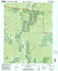
1997 Map of Grandin SW
USGS Topo · Published 2000About this map
The Current River carves a winding path through this portion of the Ozarks, serving as the central axis for the Ozark National Scenic Riverways. This late-twentieth-century revision illustrates a landscape defined by deep drainage patterns and steep ridges, such as Battleaxe Ridge, where the topography dictated early settlement and transit. Much of the land is managed as the Mark Twain National Forest, though pockets of private heritage remain visible through several family and community landmarks. Researchers will find several small burial grounds including Ponder Cemetery, Lewis Cemetery, and Vandiver Cemetery, which are often the last standing indicators of former homesteads. The presence of the Bay Nothing Boat Ramp and numerous named springs like Panther Spring and Big Spring highlight the historical and continued importance of the river for both sustenance and local travel.
Find a feature on this map
31 named features on this map. Tap any name to fly to it.
Don’t see what you’re looking for? This feature index may not catch every label — zoom into the map to look around manually.
Map Details
Editions of this 1997 Grandin SW Map
This is the sole edition of this map. No revisions or reprints were ever made.
Other maps of this area

1939 · Doniphan
USGS Topo · 1:62,500

1941 · Gatewood
USGS Topo · 1:62,500

1944 · Van Buren
USGS Topo · 1:62,500

1944 · Grandin
USGS Topo · 1:62,500

1945 · Doniphan
USGS Topo · 1:62,500

1945 · Gatewood
USGS Topo · 1:62,500

1946 · Grandin
USGS Topo · 1:62,500

1946 · Van Buren
USGS Topo · 1:62,500

1957 · Poplar Bluff
USGS Topo · 1:250,000

1959 · Poplar Bluff
USGS Topo · 1:250,000