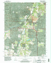
1991 Map of Grandview
USGS Topo · Published 1996About this map
The Blue River corridor anchors this detailed look at south Kansas City and its neighbors during the early 1990s. The landscape reflects intense suburban development and historical transit routes, most notably the crossing of the State Line into Johnson County. Civil engineering dominates the terrain, with the Circumferential Freeway cutting across the central portion of the sheet near Holmes Park and Dallas. These modern corridors overlay an older network of roads like Santa Fe Road and the Kansas City Southern Railway, which once served more localized agricultural and industrial centers. Residential growth is evident in established neighborhoods such as Ruskin Heights and Marlborough, while substantial green spaces like Swope Park and Longview Lake County Park preserve the natural topography along the river bends. Large memorial grounds, including Memorial Park Cemetery and Mt Moriah Cemetery, provide significant landmarks for family historians and local researchers.
Find a feature on this map
53 named features on this map. Tap any name to fly to it.
Don’t see what you’re looking for? This feature index may not catch every label — zoom into the map to look around manually.
Map Details
Editions of this 1991 Grandview Map
This is the sole edition of this map. No revisions or reprints were ever made.
Other maps of this area

1887 · Harrisonville
USGS Topo · 1:125,000

1887 · Olathe
USGS Topo · 1:125,000

1890 · Kansas City
USGS Topo · 1:125,000

1892 · Harrisonville
USGS Topo · 1:125,000

1893 · Olathe
USGS Topo · 1:125,000

1894 · Kansas City
USGS Topo · 1:125,000

1894 · Harrisonville
USGS Topo · 1:125,000

1894 · Independence
USGS Topo · 1:125,000

1934 · Independence
USGS Topo · 1:24,000

1934 · Grandview
USGS Topo · 1:24,000