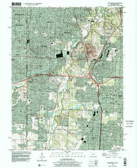
1996 Map of Grandview
USGS Topo · Published 2002About this map
The Blue River corridor anchors this landscape, marking the transition from established Kansas City neighborhoods into the industrial and residential growth of southern Jackson County. In the late 1990s, the expansion of the Circumferential Freeway and the Kansas City Southern rail line facilitated a shift from rural crossroads to suburban centers. Historic communities such as Hickman Mills and Grandview are shown during a period of significant development, while legacy landmarks like Fairyland Park and the expansive Swope Park maintain their footprint amidst the increasing density.
Find a feature on this map
49 named features on this map. Tap any name to fly to it.
Don’t see what you’re looking for? This feature index may not catch every label — zoom into the map to look around manually.
Map Details
Editions of this 1996 Grandview Map
This is the sole edition of this map. No revisions or reprints were ever made.
Other maps of this area

1887 · Harrisonville
USGS Topo · 1:125,000

1887 · Olathe
USGS Topo · 1:125,000

1890 · Kansas City
USGS Topo · 1:125,000

1892 · Harrisonville
USGS Topo · 1:125,000

1893 · Olathe
USGS Topo · 1:125,000

1894 · Kansas City
USGS Topo · 1:125,000

1894 · Harrisonville
USGS Topo · 1:125,000

1894 · Independence
USGS Topo · 1:125,000

1934 · Independence
USGS Topo · 1:24,000

1934 · Grandview
USGS Topo · 1:24,000