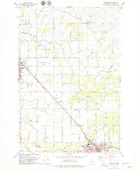
1978 Map of Grandview
USGS Topo · Published 1979About this map
The Sunnyside Canal and Roza Canal weave through this landscape, illustrating the critical irrigation infrastructure that transformed the Yakima Valley into an agricultural powerhouse. This 1970s survey captures the region between Sunnyside and Grandview during a period of established orchard and field farming. The intricate network of smaller waterways, such as Washout Creek and Sulphur Creek Wasteway, works in tandem with the primary canals to support the local economy.
Find a feature on this map
55 named features on this map. Tap any name to fly to it.
Don’t see what you’re looking for? This feature index may not catch every label — zoom into the map to look around manually.
Map Details
Editions of this 1978 Grandview Map
This is the sole edition of this map. No revisions or reprints were ever made.
Other maps of this area

1910 · Zillah
USGS Topo · 1:125,000

1915 · Prosser
USGS Topo · 1:125,000

1917 · Prosser
USGS Topo · 1:125,000

1950 · Yakima
USGS Topo · 1:250,000

1950 · Grandview
USGS Topo · 1:62,500

1951 · Grandview
USGS Topo · 1:62,500

1953 · Walla Walla
USGS Topo · 1:250,000

1958 · Walla Walla
USGS Topo · 1:250,000

1958 · Yakima
USGS Topo · 1:250,000

1961 · Yakima
USGS Topo · 1:250,000