
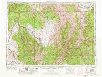
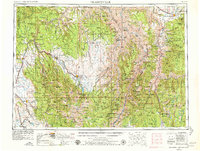
1955 Map of Grangeville
USGS Topo · Published 1964About this map
Grangeville and the high plateaus of central Idaho overlook a landscape defined by the deep canyons of the Snake River and Salmon River in this mid-century topographic survey. The rugged transition from the Wallowa Mountains in Oregon to the Seven Devils Mountains in Idaho is documented just as the region's hydroelectric infrastructure was expanding, evidenced by Oxbow Reservoir and Hells Canyon Reservoir along the state line. Agriculture and timber interests are centered around valley settlements like Enterprise and Joseph, while the Union Pacific RR provides a critical transportation corridor through the western reaches of the map near Union and North Powder. The map captures the vast reaches of the Nezperce National Forest and Wallowa National Forest, highlighting a period of intense natural resource management and the early development of modern mountain access roads like U.S. 95 and Or 82.
Find a feature on this map
170 named features on this map. Tap any name to fly to it.
Don’t see what you’re looking for? This feature index may not catch every label — zoom into the map to look around manually.
Map Details
Editions of this 1955 Grangeville Map
4 editions found

Other maps of this area

1901 · Baker City
USGS Topo · 1:125,000

1901 · Sumpter
USGS Topo · 1:125,000

1906 · Telocaset
USGS Topo · 1:125,000

1911 · Meadows
USGS Topo · 1:125,000

1915 · Pine
USGS Topo · 1:125,000

1919 · Walla Walla
USGS Topo · 1:125,000

1920 · Seven Devils Mining District
USGS Topo · 1:48,000

1921 · Walla Walla
USGS Topo · 1:125,000

1922 · He Devil
USGS Topo · 1:48,000

1924 · Kamiah
USGS Topo · 1:125,000