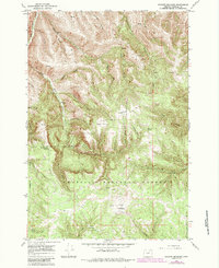
1967 Map of Granite Meadows
USGS Topo · Published 1984About this map
Umatilla National Forest encompasses the complex drainage systems shown in this mid-1960s survey, updated with forest revisions through the early 1980s. The landscape is defined by the headwaters of Birch Creek, which branches into West Birch Creek and several deeply incised gulches such as Coyote Gulch and Stanley Gulch. Settlement history is evidenced by the Pine Grove (Site) located along Birch Creek, while high-altitude terrain features like Table Mountain and South Prairie provided essential grazing land. The presence of the Lucky Strike mine and various Drill Holes scattered across the meadows and ridges suggests a history of mineral exploration in the volcanic terrain. Access was historically limited to routes like the California Jeep Tr, which navigated the transition between the Lower Bench and the timbered heights of Granite Meadows.
Find a feature on this map
46 named features on this map. Tap any name to fly to it.
Don’t see what you’re looking for? This feature index may not catch every label — zoom into the map to look around manually.
Map Details
Editions of this 1967 Granite Meadows Map
2 editions found
Other maps of this area

1953 · Pendleton
USGS Topo · 1:250,000

1956 · Pendleton
USGS Topo · 1:250,000

1967 · Nye
USGS Topo · 1:24,000

1967 · Lehman Springs
USGS Topo · 1:24,000

1967 · Granite Meadows
USGS Topo · 1:24,000

1967 · Carney Butte
USGS Topo · 1:24,000

1967 · Pilot Rock
USGS Topo · 1:24,000

1967 · Ukiah
USGS Topo · 1:24,000

1967 · Owens Butte
USGS Topo · 1:24,000
1967 · Sevenmile Creek
USGS Topo · 1:24,000