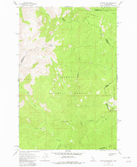
1964 Map of Granite Pass
USGS Topo · Published 1981About this map
Granite Pass serves as a critical high-altitude corridor along the divide between Idaho and Montana in this mid-1960s topographic study. The landscape is defined by the boundary of Lolo National Forest and Clearwater National Forest, where a network of historic travel routes like the Idaho Montana State Line (Pack) Trail and various pack trails traverse the ridgelines. High points such as Granite Peak and Pilot Knob overlook the headwaters of numerous drainages, including the Crooked Fork and Boulder Creek. This map reveals a wilderness managed for forestry and fire observation, evidenced by the Lookout Tower situated near BM Hill. The presence of a Jeep Trail and several pack trails highlights the area's transition from early foot and animal transit to seasonal vehicular access for forest management and recreation.
Find a feature on this map
25 named features on this map. Tap any name to fly to it.
Don’t see what you’re looking for? This feature index may not catch every label — zoom into the map to look around manually.
Map Details
Editions of this 1964 Granite Pass Map
2 editions found
Other maps of this area

1911 · Lolo
USGS Topo · 1:250,000

1913 · Lolo
USGS Topo · 1:250,000

1956 · Hamilton
USGS Topo · 1:250,000

1959 · Hamilton
USGS Topo · 1:250,000

1960 · Hamilton
USGS Topo · 1:250,000

1960 · Straight Peak
USGS Topo · 1:62,500

1964 · Hamilton
USGS Topo · 1:250,000

1964 · Lolo Hot Springs
USGS Topo · 1:24,000

1964 · Rocky Point
USGS Topo · 1:24,000
1964 · White Mountain
USGS Topo · 1:24,000