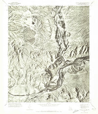
1971 Map of Granite Reef Dam
USGS Topo · Published 1972About this map
Granite Reef Dam serves as the focal point for this orthophoto study of the Maricopa County desert, capturing the critical junction of two major Arizona waterways in the early 1970s. The aerial imagery illustrates the confluence where the Verde River meets the Salt River, a vital node for the region's irrigation and water management systems. The arid landscape is dominated by the prominent rise of Mount Mc Dowell, which stands in sharp contrast to the braided river channels and alluvial fans below. Because this is an orthophotomosaic, the imagery reveals the fine-grained texture of the desert scrub and the precise engineering of the diversion structures at the dam, providing a level of surface detail that traditional line-and-tint maps often omit.
Find a feature on this map
4 named features on this map. Tap any name to fly to it.
Don’t see what you’re looking for? This feature index may not catch every label — zoom into the map to look around manually.
Map Details
Editions of this 1971 Granite Reef Dam Map
This is the sole edition of this map. No revisions or reprints were ever made.
Other maps of this area

1904 · Camelback
USGS Topo · 1:62,500

1904 · Desert Well
USGS Topo · 1:62,500

1904 · Ft. McDowell
USGS Topo · 1:62,500

1906 · Camelsback
USGS Topo · 1:62,500

1906 · Ft. McDowell
USGS Topo · 1:62,500

1906 · Desert Well
USGS Topo · 1:62,500

1913 · Mesa
USGS Topo · 1:62,500

1915 · Mesa
USGS Topo · 1:62,500

1930 · Cave Creek
USGS Topo · 1:125,000

1939 · Cave Creek
USGS Topo · 1:125,000