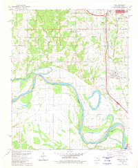
1980 Map of Grant
USGS Topo · Published 1981About this map
The Red River defines a winding border between Oklahoma and Texas, its path marked by an indefinite boundary that snakes through the river valley. The landscape is a network of floodplain features and small settlements, including the town of Grant and the community of Goodland. Significant water bodies like the oxbow-shaped Roebuck Lake and the Muddy Boggy Creek suggest a highly dynamic hydrological environment where the river has shifted over time, evidenced by the Boggy Cutoff.
Find a feature on this map
36 named features on this map. Tap any name to fly to it.
Don’t see what you’re looking for? This feature index may not catch every label — zoom into the map to look around manually.
Map Details
Editions of this 1980 Grant Map
This is the sole edition of this map. No revisions or reprints were ever made.
Other maps of this area

1901 · Antlers
USGS Topo · 1:125,000

1901 · Alikchi
USGS Topo · 1:125,000

1903 · Paris
USGS Topo · 1:125,000

1912 · Antlers
USGS Topo · 1:125,000

1925 · Antlers
USGS Topo · 1:125,000

1948 · Grant
USGS Topo · 1:62,500

1949 · Grant
USGS Topo · 1:62,500

1950 · Mcalester
USGS Topo · 1:250,000

1951 · Slate Shoals
USGS Topo · 1:24,000

1951 · Shoals
USGS Topo · 1:24,000