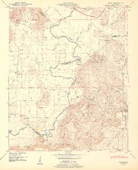
1950 Map of Grant
USGS Topo · Published 1950About this map
The Paint Rock River winds through the heart of this 1950 topography, carving a path between the steep elevations of Gunters Mountain and Nebo Mountain. This landscape reflects a transition from the river-bottom agriculture and transportation routes near Fishtrap Road to the upland settlements of Grant and Woodville. The area's social fabric is visible through its numerous country churches and family burial grounds, such as Bethel Ch and the Whittaker Cem, which dot the hollows and ridges. In the northeast, the Southern railroad and Lee Highway facilitate movement through the mountain gaps, while smaller river crossings like Hellum Ford and Maple Ford suggest an era of more localized, rural connectivity. The presence of several springs and ponds, including Big Horseshoe Pond and Manning Spring, underscores the critical role of natural water sources for the homesteads and schools like Mt Pleasant School scattered across the Marshall and Jackson county lines.
Find a feature on this map
77 named features on this map. Tap any name to fly to it.
Don’t see what you’re looking for? This feature index may not catch every label — zoom into the map to look around manually.
Map Details
Editions of this 1950 Grant Map
2 editions found
Other maps of this area

1885 · Gadsden
USGS Topo · 1:125,000

1888 · Gadsden
USGS Topo · 1:125,000

1888 · Scottsboro
USGS Topo · 1:125,000

1892 · Scottsboro
USGS Topo · 1:125,000

1892 · Gadsden
USGS Topo · 1:125,000

1895 · Gadsden
USGS Topo · 1:125,000

1903 · Gadsden
USGS Topo · 1:125,000

1936 · Columbus City
USGS Topo · 1:24,000

1936 · New Hope
USGS Topo · 1:24,000

1936 · Guntersville Dam
USGS Topo · 1:24,000