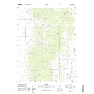
2018 Map of Grantsville
USGS Topo · Published 2018About this map
Grantsville and Union sit in the canyons of the Shoshone Mountains, representing the high-elevation settlement patterns of the Toiyabe National Forest. This 2018 survey detail shows a landscape defined by sharp elevation changes, where access is dictated by winding routes like the Grantsville Summit and Richmond Spur. The mapping reveals a dependence on mountain water sources, with numerous named points such as Indian Garden Spring, Milton Spring, and Wild Carrot Spring distributed across the slopes.
Find a feature on this map
60 named features on this map. Tap any name to fly to it.
Don’t see what you’re looking for? This feature index may not catch every label — zoom into the map to look around manually.
Map Details
Editions of this 2018 Grantsville Map
This is the sole edition of this map. No revisions or reprints were ever made.
Other maps of this area

1907 · Tonopah
USGS Topo · 1:250,000

1908 · Tonopah
USGS Topo · 1:250,000

1948 · Ione
USGS Topo · 1:62,500

1950 · Ione
USGS Topo · 1:62,500

1956 · Tonopah
USGS Topo · 1:250,000

1959 · Tonopah
USGS Topo · 1:250,000

1962 · Tonopah
USGS Topo · 1:250,000
1979 · Corral Wash
USGS Topo · 1:24,000
1980 · Black Spring NW
USGS Topo · 1:24,000
1980 · Farrington Canyon
USGS Topo · 1:24,000