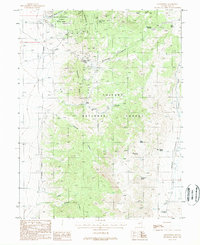
1988 Map of Grantsville
USGS Topo · Published 1988About this map
The high-desert mining district of Grantsville is the focal point of this 1980s landscape, where industrial history meets the unique fossil beds of Berlin-Ichthyosaur State Park. The map documents a terrain heavily marked by silver and antimony extraction, particularly around the Grantsville Ridge and Richmond Hill areas. Mineral interest is evidenced by the concentration of deep workings like the Alexander Shafts and the Brooklyn Shaft, alongside numerous adits and open cut mines. In the eastern section, the Toiyabe National Forest covers high summits and deep drainages, including Grantsville Canyon and Milton Canyon. This era shows the persistence of remote outposts such as Milton Ranch, while the inclusion of a cemetery and various springs like Indian Garden Spring points to the area's long-term human habitation and reliance on scarce water sources in Indian Valley.
Find a feature on this map
34 named features on this map. Tap any name to fly to it.
Don’t see what you’re looking for? This feature index may not catch every label — zoom into the map to look around manually.
Map Details
Editions of this 1988 Grantsville Map
This is the sole edition of this map. No revisions or reprints were ever made.
Other maps of this area

1907 · Tonopah
USGS Topo · 1:250,000

1908 · Tonopah
USGS Topo · 1:250,000

1948 · Ione
USGS Topo · 1:62,500

1950 · Ione
USGS Topo · 1:62,500

1956 · Tonopah
USGS Topo · 1:250,000

1959 · Tonopah
USGS Topo · 1:250,000

1962 · Tonopah
USGS Topo · 1:250,000
1979 · Corral Wash
USGS Topo · 1:24,000
1980 · Black Spring NW
USGS Topo · 1:24,000
1980 · Farrington Canyon
USGS Topo · 1:24,000