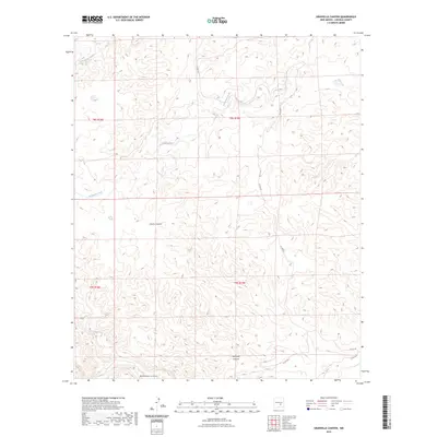
2023 Map of Granville Canyon
USGS Topo · Published 2023About this map
Granville Canyon and its complex network of seasonal drainages define this portion of Lincoln County, New Mexico. The landscape is characterized by a series of deep, branching canyon systems, including Cherry Canyon in the central portion and Blackwater Canyon along the southern edge. These landforms dictate the local movement and settlement patterns, with thin ribbons of road like Co RD 037 and Co RD e035 winding through the high-elevation terrain. Water sources are predominantly ephemeral arroyos and creeks, such as Zeufeldt Arroyo in the northwest and Archuleta Creek, which carves through the central townships. The map illustrates the contemporary Public Land Survey System divisions, marking the boundaries of t8s r18e, t8s r19e, t9s r18e, and t9s r19e. These legal grids provide a structured overlay to the otherwise labyrinthine topography of the high desert canyons.
Find a feature on this map
13 named features on this map. Tap any name to fly to it.
Don’t see what you’re looking for? This feature index may not catch every label — zoom into the map to look around manually.
Map Details
Editions of this 2023 Granville Canyon Map
This is the sole edition of this map. No revisions or reprints were ever made.
Other maps of this area

1936 · Arabela
USGS Topo · 1:48,000

1942 · Arabela
USGS Topo · 1:62,500

1955 · Roswell
USGS Topo · 1:250,000

1958 · Roswell
USGS Topo · 1:250,000

1961 · Tinnie
USGS Topo · 1:62,500

1962 · Roswell
USGS Topo · 1:250,000

1962 · Horseshoe Bend
USGS Topo · 1:62,500

1967 · White Flat
USGS Topo · 1:24,000
1967 · Elsie Canyon
USGS Topo · 1:24,000

1979 · Roswell
USGS Topo · 1:100,000