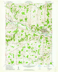
1961 Map of Granville
USGS Topo · Published 1962About this map
Denison Univ dominates the hill overlooking Granville, a village defined by its educational and transport corridors in the early 1960s. The landscape is characterized by the winding path of Raccoon Creek and the steel of the New York Central and Baltimore and Ohio railroads. The map reveals a transition from a dense village center toward the surrounding townships of St Albans and Harrison, where small crossroads like Scott Corners and Goddard Corners served as rural hubs. Local institutional history is visible in the presence of the County Home and the Union Sch near the settlement of Union Station. Topographic landmarks like Sugarloaf Hill and Parnassus Hill frame the valley, while several cemeteries, including the Welsh Hills Cem and Gaffield Cem, provide essential data points for family historians tracing early Licking County residents.
Find a feature on this map
36 named features on this map. Tap any name to fly to it.
Don’t see what you’re looking for? This feature index may not catch every label — zoom into the map to look around manually.
Map Details
Editions of this 1961 Granville Map
Other maps of this area

1907 · Thurston
USGS Topo · 1:62,500

1908 · Granville
USGS Topo · 1:62,500

1909 · Newark
USGS Topo · 1:62,500

1909 · Thornville
USGS Topo · 1:62,500

1909 · Thurston
USGS Topo · 1:62,500

1910 · Granville
USGS Topo · 1:62,500

1947 · Columbus
USGS Topo · 1:250,000

1950 · Marion
USGS Topo · 1:250,000
1958 · Pataskala
USGS Topo · 1:24,000

1961 · Columbus
USGS Topo · 1:250,000