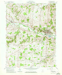
1961 Map of Granville
USGS Topo · Published 1972About this map
Granville stands as a prominent academic and cultural center in the early 1960s, dominated by the campus of Denison Univ on the heights above the village. The surrounding landscape in Licking County is defined by the winding course of Raccoon Creek and a network of smaller waterways like Griffin Run and Moots Run. The area maintains a balance between its educational identity and its agricultural roots, with numerous family-named junctions such as Scott Corners and Goddard Corners marking the rural roads.
Find a feature on this map
40 named features on this map. Tap any name to fly to it.
Don’t see what you’re looking for? This feature index may not catch every label — zoom into the map to look around manually.
Map Details
Editions of this 1961 Granville Map
Other maps of this area

1907 · Thurston
USGS Topo · 1:62,500

1908 · Granville
USGS Topo · 1:62,500

1909 · Newark
USGS Topo · 1:62,500

1909 · Thornville
USGS Topo · 1:62,500

1909 · Thurston
USGS Topo · 1:62,500

1910 · Granville
USGS Topo · 1:62,500

1947 · Columbus
USGS Topo · 1:250,000

1950 · Marion
USGS Topo · 1:250,000
1958 · Pataskala
USGS Topo · 1:24,000

1961 · Columbus
USGS Topo · 1:250,000