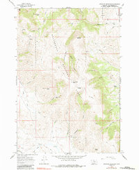
1965 Map of Graphite Mountain
USGS Topo · Published 1984About this map
Beaverhead National Forest defines this high-elevation landscape, where numerous springs and steep gulches feed the regional drainage system. The topography is dominated by prominent summits including Ellis Peak and Sourdough Peak, while Graphite Mountain serves as a central landmark for this 1960s-era survey. The map indicates a history of resource exploration, noting several prospects scattered across the drainages of Porcupine Canyon and Sweeney Gulch. A network of jeep trails and primitive paths provides the only access into these remote basins, such as Muddy Hole Basin, illustrating the isolated nature of the terrain during this period. Local water sources are carefully documented, ranging from Hewlett Spring in the south to West Kate Creek Spring near the northern boundary, reflecting the vital importance of water for both wildlife and high-country land management.
Find a feature on this map
36 named features on this map. Tap any name to fly to it.
Don’t see what you’re looking for? This feature index may not catch every label — zoom into the map to look around manually.
Map Details
Editions of this 1965 Graphite Mountain Map
2 editions found
Other maps of this area

1955 · Dubois
USGS Topo · 1:250,000

1956 · Morrison Lake
USGS Topo · 1:62,500

1958 · Dubois
USGS Topo · 1:250,000

1965 · Kidd
USGS Topo · 1:24,000

1965 · Caboose Canyon
USGS Topo · 1:24,000

1965 · Graphite Mountain
USGS Topo · 1:24,000

1965 · Deer Canyon
USGS Topo · 1:24,000
1965 · Medicine Lodge Peak
USGS Topo · 1:24,000

1965 · Dixon Mountain
USGS Topo · 1:24,000

1965 · Island Butte
USGS Topo · 1:24,000